Drones & Thermal Imaging: Aerial Insights for Firefighting and Beyond
InfraMation 2018 Application Paper Submission
Ryan M. Bracken
DroneSense, Inc.
ABSTRACT
Through a partnership with FLIR, DroneSense offers drone operators advanced thermal camera controls with industry leading situational awareness features and an integrated system of record. This affords operators, command center staff, and remote viewers an instantaneous understanding of the thermal and visible details of a scene as well as critical contextual information such as position, altitude, and heading of the aircraft collecting the video. Operators can use this information to optimize their approach to dynamic response environments as well as use DroneSense tools to automate precise and repeatable imagery collection.
INTRODUCTION
Drones are adding value to vast and increasing array of industries - spanning public safety to agriculture, industrial inspections to construction. From helping first responders gain aerial views of wildfires and natural disasters to detecting defective solar panels, this transformative technology is providing users with powerful insights into businesses and operations that until recently were cost prohibitive and physically unattainable.
Drones (or Unmanned Aerial Systems) with thermal imaging capabilities take these deployments to an entirely new level by providing users the ability to visualize what’s invisible to the naked eye. This new view on the world can help reveal the location of lost people in search and rescue missions, monitor crop health, and much more.
However, the combination of thermal imagery with dynamic, convoluted flight paths can create a significant barrier to drone operators and remote viewers turning video into actionable intelligence. In addition to interpreting the thermal aspects of an image or video, ground-based personnel must also understand drone locations, altitudes, gimbal angles and other key parameters to provide context for the thermal feed. DroneSense has partnered with FLIR to solve this challenge and has provided operators world-class thermal scene analysis capabilities within a complete drone deployment platform.
WHERE AM I?
Using the DroneSense Pilot application, drone operators can view the drone position over a selection of base layers with a simple click on “Map” (see Figure 1). This view also provides the drone’s heading, enabling the operator to orient themselves with map features using satellite imagery, street models, or even terrain. The operator can also choose to view the position, heading, and other key flight parameters for other drones operating within his or her organization to enable collaboration and deconfliction.
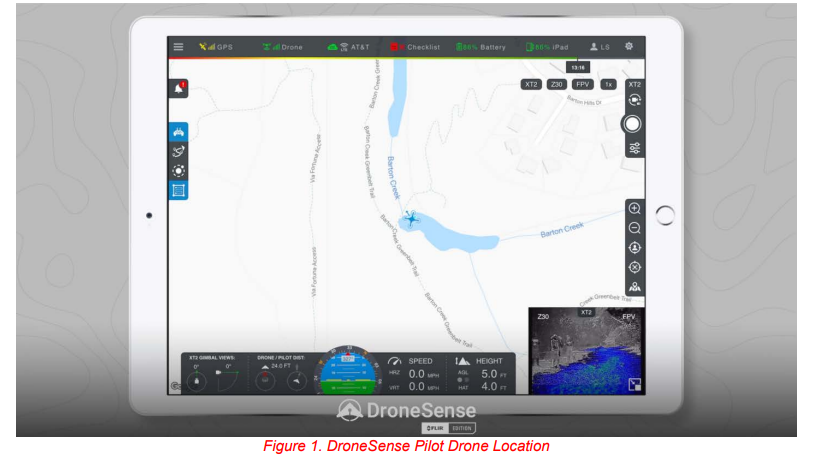
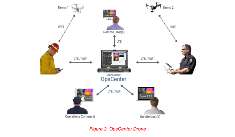
Remote viewers and command center staff can use a web browser to log into OpsCenter to securely view the same video and telemetry data from any drone operating within the user’s organization. Drone icons, markers, and video are all color-coded for each operator allowing a remote user to immediately understand the key details surrounding a video collection. The remote user can also interact with the drone operator by sharing markers, polygons, and text communications.
WHAT AM I LOOKING AT?
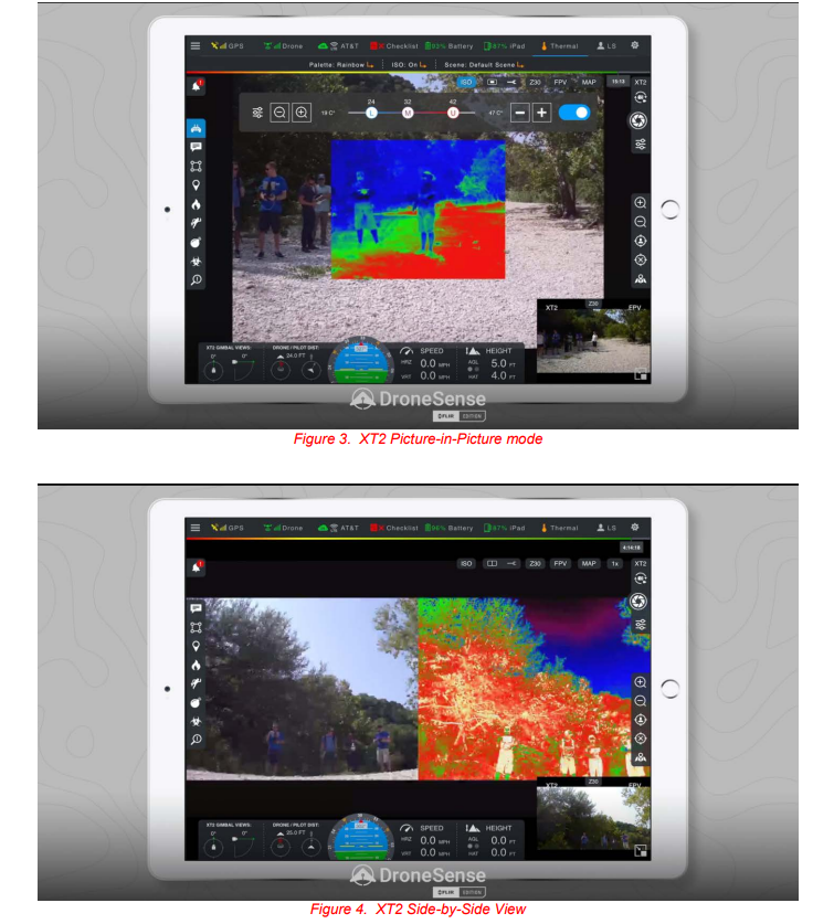
Rather than simply viewing a white-hot or black-hot thermal images in isolation, DroneSense Pilot can be configured to display the imagery from a camera such as a DJI XT2 within the context of simultaneous visible imagery. Figures 3 and 4 demonstrate two such modes; Picture-in-Picture and Side-by-Side.
Powerful insights can also be generated by fusing multi-spectral video sources. Figure 5 shows a blended visible/thermal image with Isotherm mode configured to highlight the relatively hotter portion of the gravel path located within the sunlight.
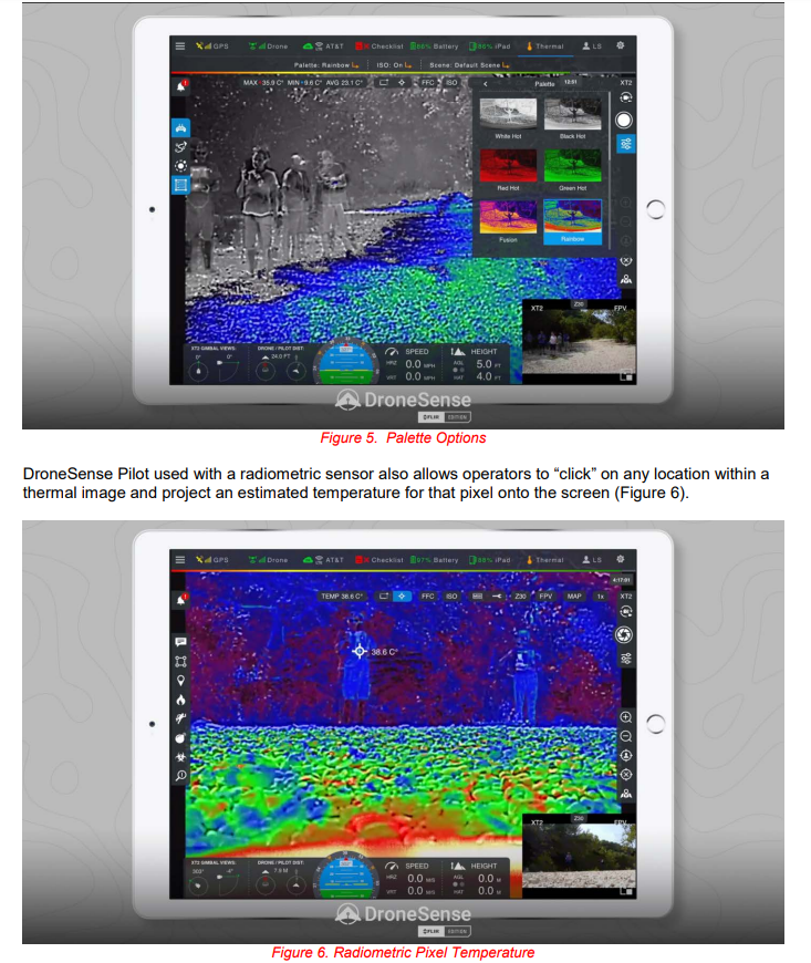
DroneSense Pilot used with a radiometric sensor also allows operators to “click” on any location within a thermal image and project an estimated temperature for that pixel onto the screen (Figure 6).
LET’S AUTOMATE THINGS
DroneSense allows you to create flight plans for autonomous missions ahead of time in Pilot or OpsCenter or even modify them mid-mission. DroneSense offers three primary autonomous flight modes: waypoints, orbits, and surveys (please see Figure 7 below). Each can be used for a single flight or saved in the DroneSense cloud to be reused in subsequent flights.
SUMMARY
In addition to providing flight control, live video-streaming, and collaboration capabilities, DroneSense provides a full system of record to seamlessly capture flight logs and other data. The DroneSense AirBase application is accessed via web browser and acts as the organization’s full asset management system. It becomes the repository of all detailed flight records; automatically logs flights from our Flight Control app; tracks training and proficiency for risk management; generates compliance and regulatory reports; enables quick e-filing and distribution of NOTAMs; updates multiple pieces of data around Pilots, hardware, and flights in real-time; and provides secure API access to the organization's data. This seamless system eliminates the issues that normally arise from incorrect manual input or transcription of data, inadvertent omission of data entry, or even the difficulty of responding to information requests from various stakeholders (including the public, courts, internal audits, etc.).
DroneSense provides a comprehensive software platform which helps organizations effectively operate their drones, make the most of their advanced thermal imaging capabilities, and understand and manage their drone program.
ACKNOWLEDGEMENTS
The author wishes to thank FLIR for the extraordinary engineering efforts that made these thermal features possible and the rich partnership they have extended to DroneSense. DroneSense is grateful to the many public safety officers that have provided their insights, feature requests and feedback to our staff. We must specifically acknowledge the members of the Austin Fire Department, Johnson County Office of Emergency Management, and the Fauquier County Sheriff’s Office for their leadership and friendship – they have indelibly impacted our software and our company.
ABOUT THE AUTHOR
Ryan Bracken leads Business Development efforts for DroneSense, Inc. Prior to joining DroneSense, Ryan spent nearly twelve years as an FBI Special Agent and has FAA Commercial/Instrument and Part 107 Remote Pilot certificates. Ryan also worked as an Aerospace Engineer for the U.S. Air Force and holds BS and MS degrees in Aeronautical Engineering from Rensselaer Polytechnic Institute.